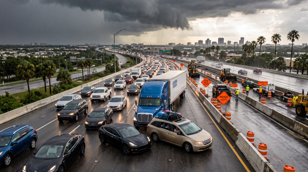
Interstate 4 runs 132 miles across the Florida peninsula, from Tampa to Daytona Beach, and it has spent years at or near the top of national rankings for fatal crashes per mile. For a road that never leaves one state and never touches a major mountain pass or a snowbelt, that is a strange distinction.
It is also a useful case study because almost nothing about I-4’s danger is accidental. The corridor is a compound of design decisions, land-use patterns, and traffic composition that each make sense individually and combine badly.
A Highway Carrying Three Incompatible Traffic Streams
Most interstates serve one dominant function. I-4 serves three simultaneously.
It is a commuter route for two large metropolitan areas. It is the primary freight corridor linking the Port of Tampa to Central Florida distribution centers. And it is the main tourist artery to the Orlando theme park complex, carrying millions of drivers annually who have never driven it before.
Why the mix matters more than the volume
A commuter knows which lane to be in a mile ahead. A freight driver needs distance to slow eighty thousand pounds. A visitor is reading overhead signs in real time and making late decisions, often while a passenger navigates from a phone that announces turns a quarter mile before they occur.
Put all three in the same lanes, and the result is a corridor where speed differentials are constant and lane changes are unpredictable. Crashes on I-4 are disproportionately rear-end and sideswipe events, which is the signature of a road where drivers are doing different things at different speeds in close proximity.
Speed differential, not absolute speed, is what produces most of these collisions. A corridor where everyone travels at 75 is safer than one where some vehicles travel at 75 and others at 45 while looking for an exit. I-4 guarantees the second condition at nearly every hour of the day.
The Design Is a Product of Its Era
I-4 opened in the 1960s to standards that would not be approved today, and the corridor grew up around the highway rather than the reverse.
Short merges and closely spaced interchanges
Through the urbanized sections, on-ramps and off-ramps sit close enough together that entering and exiting traffic must cross paths within a short distance. These weaving sections concentrate conflicts, and their crash rates run well above adjacent segments.
Left-side exits
Portions of the corridor use left-hand exits, which contradict the expectation every driver brings from elsewhere. A visitor positioned in the right lane, preparing to exit discovers the ramp is on the opposite side of the highway, and the correction happens across three lanes of traffic.
Perpetual construction
The corridor has been under sustained reconstruction for years. Shifting lanes, narrowed shoulders, temporary striping and changing patterns are the permanent condition rather than a temporary disruption, and drivers encountering them for the first time have no basis for anticipating what comes next.
Weather Compresses Reaction Time
Central Florida afternoon thunderstorms arrive fast and reduce visibility dramatically within minutes. Standing water on a road with limited shoulder drainage produces hydroplaning at speeds drivers consider normal.
The pattern is predictable seasonally and unpredictable hourly, which is the worst combination: familiar enough that regular drivers stop treating it as a hazard, sudden enough that it catches them anyway.
Sun angle deserves mention alongside rain. The corridor runs roughly east–west, which places the sun directly in drivers’ eyes during the morning and evening commutes for much of the year. Glare at the moment traffic is densest is a quietly significant contributor that never appears in a crash report as a cause.
Where the Data Actually Lives
Rankings circulate widely and are often built on inconsistent methodology. The primary sources are better. The Florida Department of Transportation safety office publishes the state’s crash data and safety program information, and the state crash dashboard allows crash counts to be examined by county and roadway rather than through a national aggregator’s summary.
Anyone involved in a collision obtains the official report through the state’s crash report portal, where reports remain confidential to the involved parties for the first 60 days.
Why Fault on This Corridor Is Genuinely Contested
According to Matthew A. Rabin, Partner and Managing Attorney of RTRLAW’s personal injury litigation division in Central Florida and a former in-house trial attorney for an insurance carrier, multi-vehicle collisions in weaving sections rarely produce a clean account of what happened, because each driver experienced a different fragment of the sequence and the officer arrives after everything has moved. Since roadway geometry and construction striping frequently explain a crash better than any driver’s recollection, car accident lawyers in Tampa look at the lane configuration in force on the date of the crash rather than the configuration in place when the case is reviewed months later on a corridor under constant reconstruction; those are often not the same road.
Driving It With Less Exposure
Position for exits well in advance, and verify whether your exit is left or right before you need it. Increase following distance beyond what feels necessary, since the vehicle ahead may stop for something you cannot see. Treat construction zones as speed reductions rather than suggestions, and avoid lingering beside a truck where neither of you can see the other.
And if a storm arrives, slow substantially rather than proportionally. Hydroplaning does not announce itself, and the corridor gives you very little room to recover once it starts.